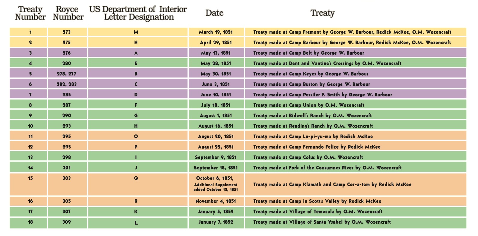
The Royce Number designation on this legend refers to the numbering system used by C.C. Royce to represent the 1851-1852 treaty lands reserved for the California Indians. See Charles C. Royce, Indian Land Cessions in the United States, Bureau of American Ethnology Eighteenth Annual Report, vol. 2, Washington, D.C.: Government Printing Office, 1899.
Treaty “O” was made with a certain cultural group(s) setting apart reserved lands near Clear Lake. Treaty “P” was made with other cultural group(s) requiring them to move to the reserved lands near Clear Lake. These treaties represent the same reserved lands despite the fact that they were different treaties negotiated on different dates and with different parties.
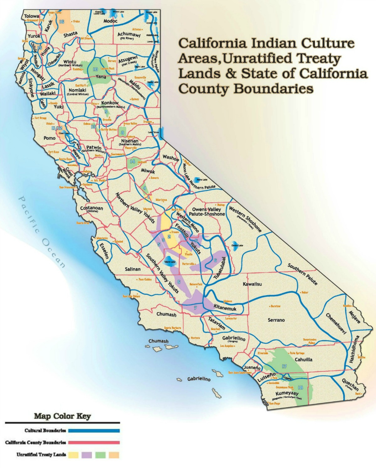
California Indian Culture Areas, Unratified Treaty Lands & State of California Boundaries Map
State of California County Boundaries Sources:
The California State Association of Counties (CSAC) is an organization that represents the counties before the California legislature, administrative agencies and the federal government. CSAC also provides historical information about how California’s counties were created and related maps, along with a map of current county boundaries.
For a contemporary map of California counties (U.S. Census, 2000), click here
For a brief history of how California’s 58 counties were created and related maps, click here
For information about California County Structure, click here
For information about the Role of California Counties, click here
https://archive.calvoter.org/voter/maps/index.html, accessed November 6, 2019.
California Culture Areas and Unratified Treaty Lands Sources:
D’Azevedo, Warren L. (ed.), Great Basin, Handbook of North American Indians Vol. 11, Washington, D.C.: Smithsonian Institution, 1986, viii- ix. Information used with permission.
Documents Relating to the Negotiation of Ratified and Unratified Treaties with Various Indian Tribes. Unratified Treaties, 1821-1865 (National Archives Microfilm Publication T494, Roll 8); Records of the Bureau of Indian Affairs, Records Group 75, National Archives and Records Administration, Washington, D.C.
Donley, Michael W., and Stuart Allen, Patricia Caro, Clyde P. Patton. Atlas of California. Culver City, Pacific Book Center, 1979, 8.
Heizer, Robert F., (ed.), California, Handbook of North American Indians Vol. 8, Washington, D.C.: Smithsonian Institution, 1978, viii- ix. Information used with permission.
Map of North American Indian Languages, compiled by E.F. and F. M. Voegelin. Rand McNally and Company, 1966.
Ortiz, Alfonso, (ed). Southwest, Handbook of North American Indians Vol. 10, Washington, D.C.: Smithsonian Institution, 1983, viii- ix. Information used with permission.
Royce, Charles C. Indian Land Cessions in the United States, Bureau of American Ethnology Eighteenth Annual Report, vol. 2, Washington, D.C.: Government Printing Office, 1899.
Voegelin, C.F. and F.M. Voegelin. Classification and Index of the World’s Languages. New York: Elsevier, 1977.
Acknowledgements:
In 2006, production and publication of the map of California Indian Culture Areas, Unratified Treaty Lands & State of California County Boundaries was supported in part by the Institute of Museum and Library Services, under provisions of the Library Services and Technology Act (LSTA), a federal program administered by the California State Librarian. It is provided courtesy of the California State Library and used with permission.
Disclaimer:
This map was created and produced solely for educational and informational purposes. Information contained in this map and on this website page is for illustrative purposes only, and is not meant to be a precise legal or geographic representation. The boundaries, names, and designations used on this map do not imply official endorsement, recognition, or the delimitation of any territories or frontiers. This map does not represent an authoritative legal survey and should not be used to determine legal jurisdiction, property ownership, or treaty rights. County boundaries are contemporary (2026). Duplication of any part or all of this map and its content is not meant for unauthorized or commercial purposes, distribution, or use in any manner.
Paper copies of the California Indian Culture Areas, Unratified Treaty Lands & State of California County Boundaries map are available for purchase from the California State Library Store link:
http://www.zazzle.com/castatelibrary
http://www.zazzle.com/california_indian_culture_areas_poster-228028532980896889